You’ll find 15 can’t-miss Georgia hikes that match every mood and pace, from Springer Mountain’s Appalachian Trail hush to Blood Mountain’s granite reward and Brasstown Bald’s sunrise panorama. Walk wooden boardwalks at Jekyll and Okefenokee, chase thunderous falls at Anna Ruby and Tallulah Gorge, and watch wild horses on Cumberland Island. Trails range from short loops to rugged multi-day routes, with practical tips for permits and gear—keep going to see full list and planning notes.
Key Takeaways
- Build a balanced list featuring summits, waterfalls, gorges, coastal islands, and rugged backcountry trails across north and southeast Georgia.
- Must-hit examples: Blood Mountain, Brasstown Bald, Anna Ruby Falls, Tallulah Gorge Rim, Cloudland Canyon, Cumberland Island, Jack’s River.
- For waterfalls and wet sections, use sturdy shoes and trekking poles for slick stone steps, mossy boulders, and steep switchbacks.
- For backcountry routes like Jack’s River, reserve campsite permits, follow quotas, and use a high-clearance vehicle to reach Long Creek.
- Time rim and summit hikes for golden hour, carry a light jacket and binoculars, and practice Leave No Trace principles.
Springer Mountain (Appalachian Trail Section)
A stone marker crowns Springer Mountain, the southern terminus of the Appalachian Trail, and it’s the kind of place that makes you feel both small and ready for something big. You’ll stand there, breathe in pine-sweet air, and understand why hikers keep returning to this trailhead history — it’s a gateway to long days and found quiet. The path ahead is simple but honest: rocky stretches, rhododendron tunnels, and views that reward steady steps. You’ll meet fellow travelers at shelters, share stories, and practice shelter etiquette that keeps everyone safe and rested. Bring light gear, a curious heart, and the willingness to move slowly when you need to. Hiking here isn’t just about miles; it’s about claiming space for freedom, leaving less trace, and coming back home a little more yourself. Trust the trail, honor others, and let each step expand the map of who you are today.
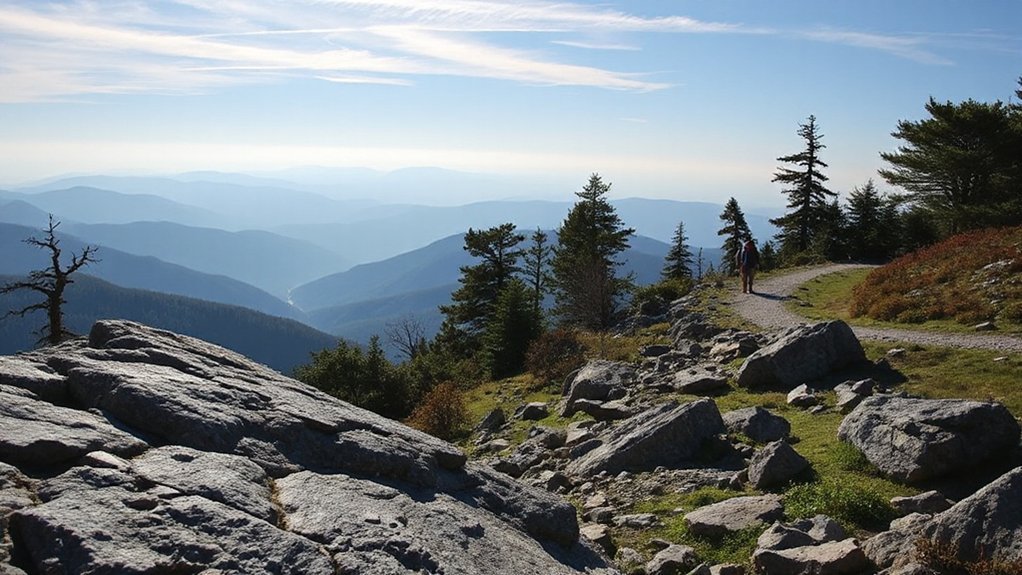
Blood Mountain via Byron Reece and Appalachian Trail
Granite outcrops and pine-scented wind greet you on the climb to Blood Mountain via the Byron Reece connector and the Appalachian Trail, and you’ll know right away why hikers call this stretch a must-do: it’s short, steep, and rewarding. You’ll follow rocky steps and sweeping ridgelines, feeling each breath open toward freedom. The summit gives wide views and a chance to rest at the historic shelter; practice shelter etiquette by keeping noise low, packing out trash, and sharing space with kindness. Byron Reece’s poet legacy whispers on trailside plaques and in wild rhododendron shadows, reminding you to move slowly and savor lines of thought. You’ll meet fellow travelers, swap route tips, and decide whether to linger for sunset. This hike asks for sensible boots, water, and curiosity, and returns solitude and community in equal measure—simple, honest gifts for anyone who wants a clear, brave escape into Georgia’s woods.
Brasstown Bald Summit Trail
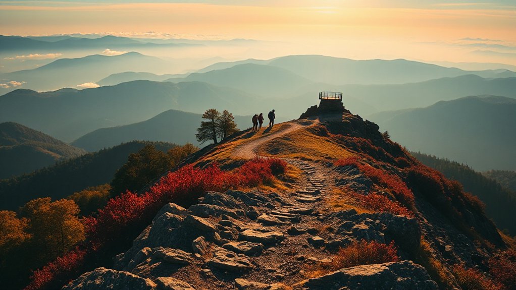
When you climb the short, steep trail to Brasstown Bald’s summit, you’ll feel the air open and a vast panorama reward every step. You move through crisp forest, each switchback sharpening anticipation until the ridge unfolds. At the top, you can stand where four states seem to breathe together; sunrise views ignite the sky and stretch promises across ridgelines. Bring a light jacket and curiosity—you’ll want to linger. A historic fire tower nearby frames the horizon and invites you to imagine nights spent watching stars and storms. The trail’s brief intensity gives you a clear, earned freedom: no long slog, just pure payoff. You’ll find benches, interpretive signs, and a visitor center that respects the landscape rather than replaces it. Whether you’re chasing early morning light or stealing a quiet afternoon, Brasstown Bald rewards you with perspective, calm, and that sense of being where you’re meant to be.
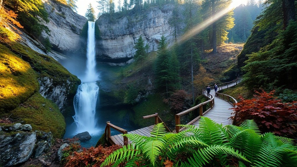
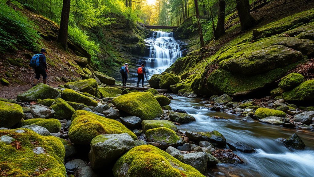
Anna Ruby Falls Loop
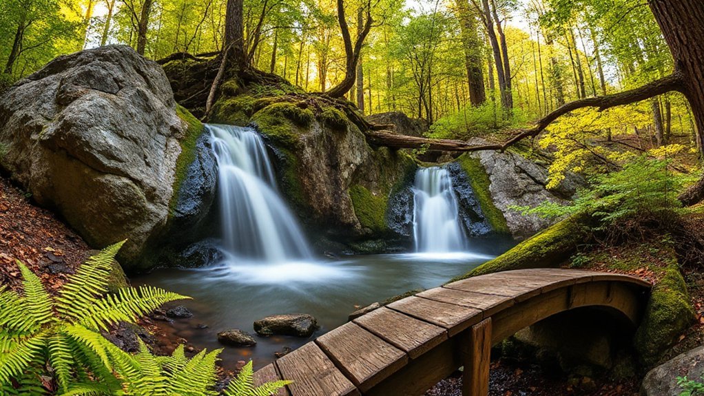
Twin-waterfall spectacle greets you at Anna Ruby Falls, where Laurel and Curtis creeks join and tumble into a lush, fern-lined gorge. You step onto a short, accessible loop that lets you savor the sound and spray without committing to a long trek. Wooden walkways and a graceful bridge crossing bring you up close to both falls, offering steady vantage points for cascade photography and quiet reflection. The path’s gentle inclines respect your pace; you’ll feel free to pause, breathe, and compose shots or simply watch water carve rock. Rangers keep the area welcoming and trails well-marked, so you can wander confidently. If you crave a nature break that’s both immediate and restorative, this loop delivers—intimate scenery, vivid green ferns, and the kind of moving water that resets your senses. You’ll leave lighter, inspired to chase more Georgia trails. Pack water, comfortable shoes, and an open heart for adventure.
Tallulah Gorge Rim Trail
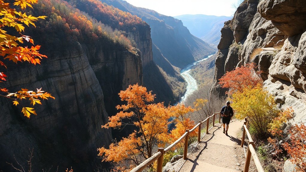
If Anna Ruby’s gentle loop reset your senses, the Tallulah Gorge Rim Trail will stir them again—this time with sheer cliffs, panoramic overlooks, and a sense of wide, thrilling space. You’ll walk along forged paths that reveal gorge geology in layers, spires, and river-carved history. Wind opens your chest; each overlook feels like permission to breathe deeper and choose your next horizon. Bring binoculars for raptor viewing; hawks and eagles patrol the thermals and make the canyon feel alive. The trail is accessible in sections, so you can craft a short pilgrimage or a full-day roam. Respect the edge, tread lightly, and let the canyon teach you quiet awe. Here are four ways to make the visit yours:
- Time your hike for golden hour light.
- Pack a picnic and linger at an overlook.
- Carry binoculars for raptor viewing.
- Study trail maps to customize distance.
Raven Cliff Falls Trail
Raven Cliff Falls Trail is a mist-kissed path that draws you through rhododendron tunnels and mossy rock to a dramatic drop of water you can almost taste in the air. You’ll feel the pull to explore as the gorge narrows and the roar grows; the footpath winds steady, offering benches and viewpoints where you can pause and breathe. Trail history sits in the stones and old railings — people have come here for generations to find solace and challenge. As you descend, listen for the slap of trout and the chatter of warblers; Wildlife viewing is rich here, from salamanders under logs to hawks riding thermals above. You’ll move at your own pace, choosing stretches or a full loop, letting the spray and greenery reset your tempo. Pack water, respect the fragile banks, and leave only footprints; freedom here feels simple and real. Let the trail open your spirit.
Cloudland Canyon West Rim and Waterfall Trails
You’ll find sweeping West Rim overlooks that make every step feel worth it. The Waterfall Loop Trail guides you past roaring cascades and quiet pools, perfect for photos and a peaceful pause. Trails range from moderate rim walks to steeper, rocky sections, so lace sturdy boots and expect some elevation change.
West Rim Overlooks
A sunlit ledge at the West Rim gives you an immediate sense of why Cloudland Canyon draws people back—sweeping cliffs, layered ridges, and the steady rush of waterfall spray combine into a view that feels both grand and intimate. You can stand there, breathe deep, and plan a simple sunset photography session or a quiet morning escape. Respect the edge, follow park safety guidelines, and you’ll feel free to explore with confidence. Trails are short but the vistas feel endless; you’ll trade minutes for memories. The overlooks invite short walks and lingering pauses.
- Pick a ledge that suits your comfort.
- Time visits for golden light.
- Pack water and follow Safety Guidelines.
- Leave no trace; savor freedom.
Waterfall Loop Trail
Waterfall-loop trail blends cliffside drama with shaded, fern-lined steps, and you’ll feel the canyon’s pulse as you descend from the West Rim toward the thundering falls. You move with purpose, breathing cooler air, following spray-scented paths where rock tells stories through erosion patterns etched over millennia. Pause at ledges to watch water carve curves and imagine the freedom of landscapes that keep changing. Ferns and stone invite close observation; practice simple moss identification—note texture, color, and growth habit, to connect deeper with this living stonework. The loop rewards curiosity: a steady rhythm of sight and sound, sudden clearings, and the raw joy of standing beside plunging water. You’ll leave refreshed, carrying a quieter, wilder sort of freedom. Bring a camera and an open heart.
Difficulty and Terrain
Although the two routes share the same canyon, their terrain and effort feel distinct: the West Rim Trail rolls along exposed ridgelines with packed dirt, occasional rock outcrops, and gentle climbs, while the Waterfall Trail plunges sharply into the gorge with long stone steps, steep switchbacks, and sections that get slick from spray. You’ll choose freedom: the West Rim rewards steady pacing and views, the Waterfall demands focus and sure footing.
- West Rim: steady dirt, exposed views
- Waterfall: steep steps, slick rock
- Gear: sturdy shoes, trekking poles
- Tips: slow descents, watch footing
Check Trail grading notices, expect varied surfaces, respect Footing hazards near wet ledges. Pack sturdy shoes, poles, water. Enjoy the canyon and hike at your pace and breathe in open freedom.
Panther Creek Falls (Cohutta Wilderness)
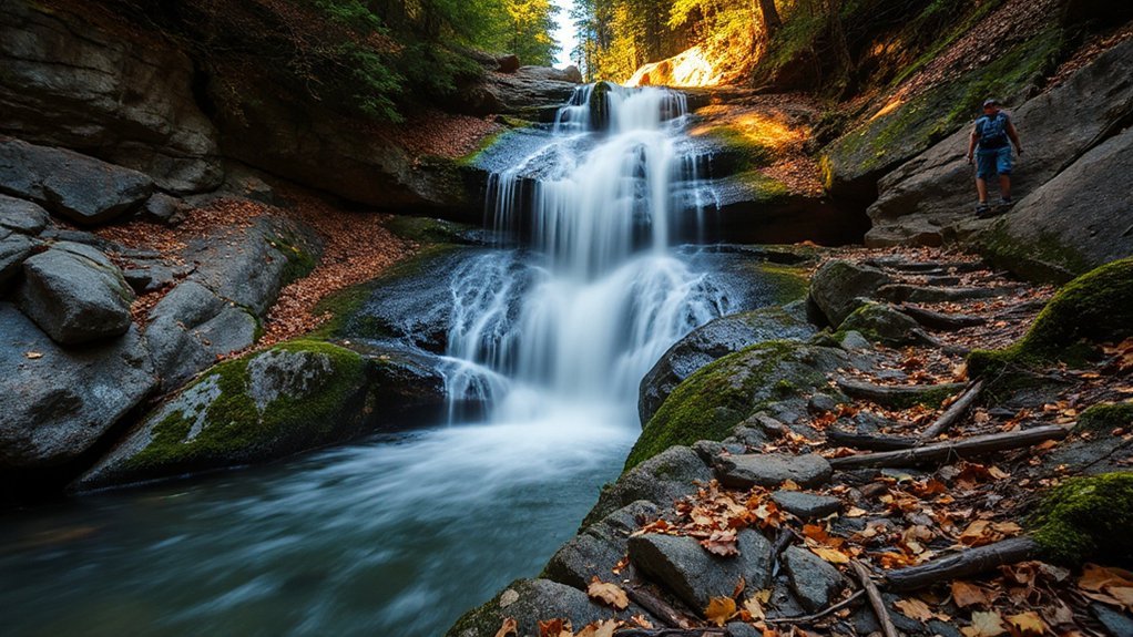
Rock slabs and moss-covered boulders guide you to Panther Creek Falls in the Cohutta Wilderness, where a two-tiered cascade plunges into a fern-fringed pool that invites quiet reflection. You’ll feel the pull of open country as you pick your way across Granite outcrops, pausing to admire Native flora that clings to crevices and carpets the forest floor. The trail rewards steady steps with viewpoints that feel yours alone; spray cools your face and the water’s rhythm eases thought. You can sit on a sun-warmed rock, breathe deep, and let plans widen like the valley before you. Pack light, move deliberately, and respect the wild—leave no trace so freedom endures. Short side paths explore ridgelines and quiet hollows; each turn offers space to roam and room to be still. You’ll leave with a clearer head, a softer pace, and the kind of calm only a waterfall woods can give.
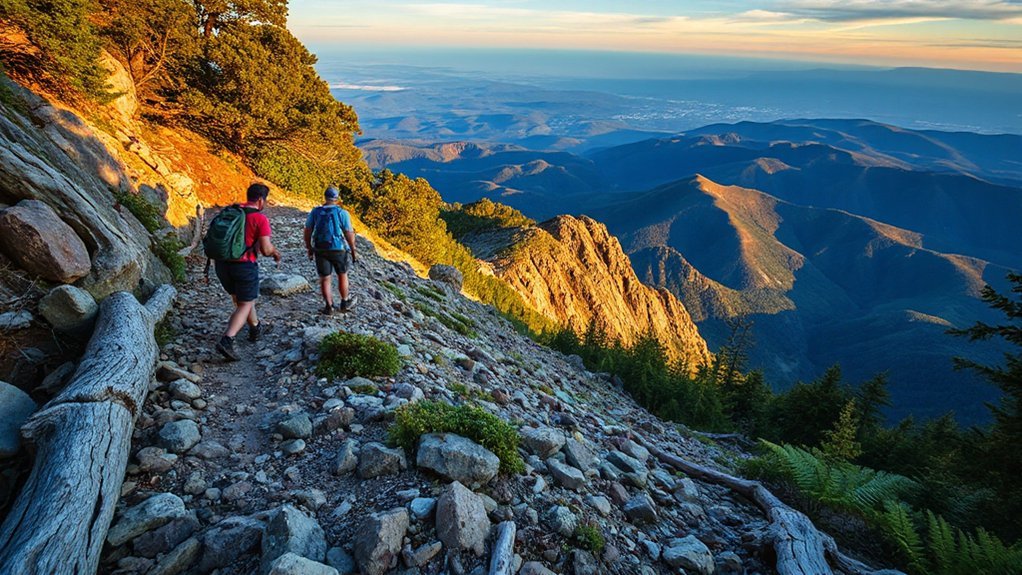
Jack’s River Trail to Jacks River Falls (Long Creek)
You’ll hike the rugged 16-mile Jack’s River Trail to the 70-foot Jacks River Falls, where mossy rocks and rushing water reward steady steps. Expect frequent river crossings, primitive campsites, and scenic overlooks that make each mile memorable. Plan access carefully—Forest Service roads lead to the trailhead and you’ll need backcountry permits or campsite reservations when required to protect the area.
Trail Highlights
When you hike Jack’s River Trail to Jacks River Falls, you’re stepping into a wild, watery world where frequent creek crossings, dense rhododendron tunnels, and limestone cascades keep every mile interesting. You’ll find moments of solitude, splash through clear pools, and feel liberated by the river’s rhythm. Trail highlights include vivid Seasonal flora and unexpected Wildlife sightings that reward patient eyes. Expect rugged footing and river-born melodies that pull you onward. Embrace sun-dappled boulders and quiet swimming holes. Practical joys and simple freedoms shape every step:
- Cascades: limestone drops and spray.
- Rhododendron corridors: scented, cool shade.
- Creek crossings: playful, rhythm-setting challenges.
- Pools & falls: perfect for reflection and cooling off.


You’ll leave soaked, refreshed, and quietly proud of the miles you claimed today, friend.
Access & Permits
After enjoying the falls and rhododendron corridors, you’ll want to know how to get to Long Creek and what permissions are involved. You’ll drive rough forest roads—high clearance helps—then park at the trailhead and step into wild space that feels like your own. The Forest Service requires permits for overnight stays; check Online Reservations early in peak season to secure your spot. Day hikes typically don’t need permits, but special events or group sizes may trigger Permit Fees or additional rules. Pack light, respect campsite quotas, and carry proof of reservation. With freedom comes responsibility: follow Leave No Trace, stick to designated campsites, and relish the simple joy of earning every mile to Jacks River Falls. Ask rangers for latest conditions and briefings daily.
Sweetwater Creek State Park (Red Trail)
The Red Trail at Sweetwater Creek State Park invites you on a 4.2-mile loop that hugs the creek, climbs gentle ridges, and brings you to the haunting Civil War–era mill ruins—it’s a route that balances solid exercise with peaceful scenery and a touch of history. You’ll feel free as you follow shaded paths where Riparian ecology thrives, and you’ll pause at stark Industrial ruins that echo past industry and conflict. The trail moves steadily, offering creekside views, forested climbs, and quiet benches for reflection. You’ll leave refreshed, grounded, and ready for more.
- Creekside vistas and wildlife sightings.
- Interpretive signs that explain the mill and local ecology.
- Moderate climbs that reward you with sweeping outlooks.
- Well-marked loop that returns you to the parking area.
Bring water, shoes, and curious spirit; this loop invites you to roam, reflect, and reclaim some freedom.
Kennesaw Mountain Historic Battlefield Trail
Kennesaw Mountain’s rocky summit rewards your climb with wide panoramas and a powerful sense of place, where preserved earthworks and interpretive signs tell stories of Civil War strategy and sacrifice. You’ll follow well-marked trails that wind through hardwoods and open ridgelines, passing monuments and trenches that remind you why this ground matters. Move at your own pace, breathing freely and deeply as history unfolds beneath your feet and the skyline stretches. Interpretive markers help you imagine troop movements, while benches invite pause to take in the view. Aim for late afternoon—the light softens and park delivers Sunset Views like a quiet benediction. The trail is accessible to many, offers clear maps, and rewards curiosity and perseverance. Whether you’re seeking reflection, a strong workout, or a chance to stand where past choices shaped the future, this historic battlefield trail lets you connect to landscape and liberty and living history.
Black Rock Mountain State Park Panorama Trail
You’ll love the Panorama Trail at Black Rock Mountain State Park for its sweeping overlooks that reward every step. Don’t miss Rattlesnake Point and the Blue Ridge overlooks, where 360-degree mountain panoramas stretch for miles. The loop is about 1.7 miles with moderate climbs, so you’ll get a solid workout without committing to a full-day trek.
Best Viewpoints
When you climb onto the Panorama Trail at Black Rock Mountain State Park, you’ll find sweeping 360-degree views that make every step worth it—craggy ridgelines, layered valleys, and incredible sunrises or sunsets that glow through the Appalachian peaks. You’ll stand where freedom feels wide; choose a ledge, breathe, and let the horizon reset you. Seek Sunrise Spots for gold light and quiet, or find natural Stargazing Platforms when night opens and constellations spill over ridges. Each viewpoint invites reflection and bold photos. Pack light, stay present, and honor the silence. Your reward is perspective—a vivid, unhurried connection to wild space you can carry home.
- Cliffside overlook at dawn
- West-facing promontory for sunset hues
- Ridge-top clearing ideal for stargazing
- Secluded bench with panoramic valley views
Distance & Difficulty
Although relatively short, the Panorama Trail packs a satisfying uphill and some rocky, rooty sections that make it feel more than a simple stroll. You’ll cover roughly 2.3 miles round-trip, with intermittent steep pitches that deliver about 300–400 feet of elevation gain depending on your route. Trails here reward steady effort, so use pacing strategies like short, steady steps on climbs and quick recoveries on flats. You can pause at overlooks without losing momentum; breathe, take photos, and keep going. The footing asks attention, so comfortable shoes matter. This hike lets you move freely while still challenging yourself — it’s approachable for many but honest about effort, offering a small, true mountain moment that makes freedom feel earned. Bring water, a map, and steady curiosity.
Cumberland Island National Seashore — Dungeness and Sea Camp Trails
A walk beneath the island’s live oaks will lead you past the evocative ruins of Dungeness and out to the salty hush of Sea Camp; you’ll see wild horses grazing, wide marsh vistas, and quiet beaches as the trails weave history and wilderness together. You can lose track of time exploring sandy paths, peering into tide pools, and watching wild horses move like living history. These trails invite you to wander freely, breathe clean air, and feel small in the best way.
Beneath live oaks, ruins, wild horses, and the hush of Sea Camp invite quiet wandering.
- Dungeness ruins — walk among decayed grandeur and oak-shaded lanes.
- Sea Camp shoreline — listen to surf, hunt shells, discover tide pools.
- Marsh overlooks — pause for migrating birds and endless horizons.
- Backcountry paths — cycle or hike for solitude and open sky.
Bring water, a light pack, and respect for wildlife; the island rewards quiet curiosity. Stay flexible, follow tides, and savor each free moment.
Jekyll Island North End Trail and Maritime Forest Boardwalk
If you loved the quiet ruins and wild horses of Cumberland, you’ll find a different kind of magic on Jekyll’s North End Trail and Maritime Forest Boardwalk. You’ll wander boardwalks that lift you above saltmarsh and live oaks, sensing ocean air and nearly endless sky. The trail feels freeing: you can set your pace, pause to watch shorebirds, or follow a sandy path toward hidden beaches. Interpretive signs explain dune restoration and the careful work that keeps dunes and maritime forest resilient. That work creates a genuine birdwatching habitat where warblers, ospreys, and shorebirds stop during migration. You’ll appreciate how preserved spaces let nature take the lead while you simply move through it. Bring binoculars, a light jacket, and curiosity. Morning and late afternoon offer the best light and quieter trails. This short, accessible loop rewards you with calm, open views and a reminder why protecting landscapes matters.
Okefenokee Swamp Boardwalk and Swamp Trail
Moss-draped cypress trunks frame the Okefenokee’s boardwalk, inviting you into a slow, watery world where turtles sun, herons stalk, and the air hums with insects and song. You follow planks over blackwater marshes, feeling small and thrilled, free to move at your own pace. Signposts point to the Swamp Trail, observation platforms, and a ranger station where you can book Canoe Tours for deeper exploration and organized Gator Viewing if you want an up-close look without worry. Bring water, a hat, and curiosity; the trail rewards quiet attention with close encounters and wide horizons.
- Walk the boardwalk at sunrise for soft light and solitude.
- Hike the Swamp Trail to see pitcher plants and wading birds.
- Join Canoe Tours to glide into the heart of the swamp.
- Try guided Gator Viewing for safe, respectful sightings.
You’ll leave quieter, lighter, and ready to chase more wild, open days very soon.
Frequently Asked Questions
Do I Need Permits or Backcountry Reservations for These Trails?
Generally, you don’t need Wilderness permits for day hikes, but some areas require backcountry permits for overnight trips. You’ll want to check specific trail regulations and secure any Backcountry reservations early during peak season. Plan ahead, respect limits, and you’ll keep wild spaces open and free for future adventures. Grab a map, leave no trace, and let the forest restore you—responsibly and with the freedom you crave, and enjoy it.
Are Dogs Allowed, and Are Leash Rules Enforced?
Yes dogs are usually allowed, but leash rules vary and rangers often enforce them. You’ll want to keep your dog leashed unless a specific area allows off leash freedom. Service dogs are always permitted and protected, so don’t hesitate to bring one. Check trailhead signs or park websites before you go, and respect closures and others’ space so everyone can enjoy wild places with the liberty you crave right now.
Where Can I Park and Are Fees Required?
You’ll feel like you own the whole valley—park at designated trailhead parking lots or roadside pullouts and you’ll be set. Most state and national park trailheads offer clearly marked spaces; some smaller preserves have limited spots. Expect nominal parking fees at popular sites, though many wilderness areas are free. Pay kiosks, apps, or self-pay envelopes are usually common. Bring cash or card, and arrive early to claim your favorite spot.
Is Cell Service Available Along These Trails?
Cell service varies a lot along those routes; you shouldn’t rely on it fully. Bring coverage maps and set up offline navigation before you go, and you’ll feel free to explore. Download maps, route GPX files, and emergency info while you have signal. Trust your instincts, share plans with someone, and charge backup batteries. You’ll enjoy wide-open trails more when you know you’ve prepared for spotty reception and stay adventurous.
What Wildlife Hazards (Ticks/Bears) and Precautions Should I Take?
You’ll encounter ticks and occasional bears, so prioritize Tick Prevention and practice Bear Awareness. Wear long sleeves and treat clothing with permethrin, check daily for ticks, and carry repellent. Make noise on trails, store food in bear-resistant containers, hang food when necessary, and travel in groups. You’ll respect wildlife and protect your freedom to explore—stay alert, prepared, and compassionate to keep yourself and wild neighbors safe every trip ahead, always.
Conclusion
You’ve walked these trails and felt Georgia’s hush settle into your bones, and you’ll carry its green beyond any map. You won’t forget the summit hushes, river songs, or marsh mornings that taught you to breathe again. Go back when you need courage; leave footprints like notes in an old diary by candlelight. Trust the trail—it’s here to remind you who you are and how wide your heart can grow every single season and mile.